Is it possible to preserve and maintain multiple layers of contextual information derived from archaeological investigations within an easy to use digital artifact collection management system and also to provide collection specialists, researchers, and students with a visual mode of spatial data interaction?
Geographic information is qualitative or quantitative information that can be located either on or below the surface of the earth. It is distinguished from other types of information in that it is multidimensional, requiring a minimum of two coordinates to define location.
A Geographic Information System is the combination of skilled persons, spatial and descriptive non-spatial data (attributes), analytic methods, and computer software and hardware organized to create, manage, analyze, store, and deliver information about geographic space through geographic presentation.
The application of computer-based collections management systems is not unique; however, the application of GIS is. This can be attributed to a couple of key factors. The first involves prevailing concerns over the costs associated with developing and implementing changes to an established collection managementsystem. The second deals with collection specialists’ unfamiliarity with the program's capabilities and software. These practical concerns are often cited for maintaining existing collection management strategies. As such, the potential of GIS as a valuable visual interface in this realm remains largely untapped.
 |
| Example of GIS (Geographic Information Science) functionality in an artifact collection management system |
What most distinguishes GIS from other computer based mapping programs is its capability of linking spatial and non-spatial data. Another element unique to GIS is that within a spatial database, data are stored and organized into layers, each of which represents a different theme. These layers can be thought of as analogous to a collection of traditional paper maps, with each individual sheet displaying a different component of the study area. Whereas a traditional map may depict individual elements such as building, canal, and land contour locations all on a single sheet, GIS provides a view into a spatial database through a map-based interface that overlays and collectively displays each element as a separate layer.
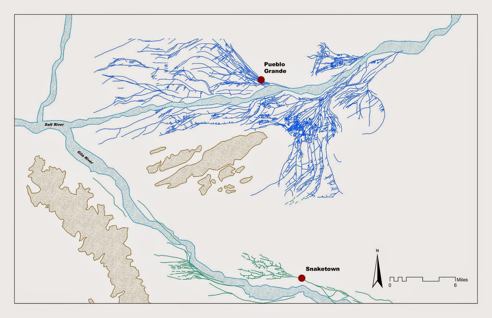 |
| Map of rivers, Hohokam canals systems created with |
This ability is among the most powerful and most frequently used features of GIS . Layering of spatial data can be done for basic visual comparison, but is also how GIS integrates and analyzes two or more layers of geographic information. The visual domain has become one of the most important ways of communicating spatial phenomena to a wide range of interests, and the ability to simultaneously visualize diverse individual data layers on a map makes GIS a powerful analytical tool. The prehistoric canals, site locations, and rivers depicted collectively within the maps displayed in Pueblo Grande’s current exhibition Supply and Demand, were created and analyzed with GIS .
Ironically, archaeology, an inherently destructive process, is often utilized to record and preserve the archaeological record. During archaeological investigations, artifacts as tangible elements of the archaeological record are physically removed from their original contexts. The results of these investigations culminate in databases, manuscripts, reports, and books where the artifacts’ contextual information resides as “data”. Artifacts are further distanced from their associated contexts when they are accessioned and curated in a museum.
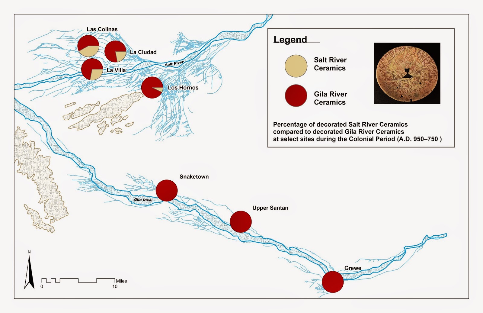 |
| Map of Hohokam canals and the results of ceramic analysis created with |
 |
As such, artifact collections become increasingly “isolated” from their contexts as they travel through the archaeological and curatorial processes. GIS can easily re-establish the lost connection between artifacts and their associated contexts via its ability to assemble, store, and graphically display information about an artifact in “one place” and tie it to a meaningful geographic location. In essence, GIS incorporated within a collection management system provides the collection specialist or researcher with a “one-stop shopping” capability to access all the data related to a collection, which otherwise might not be readily available.
Limited access to “grey literature” or attempts to parse out pertinent information from extensive and complicated digital databases is a familiar scenario for collection specialists, researchers, and students. This situation coupled with the logistical reality that collections and their associated documentation are often distributed across various locations provides an impetus for collection management specialists to explore viable alternatives to current labor intensive collection management processes. GIS offers the collection management specialist with this alternative, which once established will increase the value of the collection as a research and learning resource.
By Stephen Reichardt, Museum Aide